
Google Earth Unearths Human Ancestor Clues
Google Earth helps scientists unearth possible human ancestor sites, offering a fascinating glimpse into our past. From analyzing satellite imagery to identifying potential archaeological sites in remote regions, this innovative approach is revolutionizing human ancestry research. This exploration delves into the historical context of human ancestor research, highlighting the tools and methodologies employed, and showcases how Google Earth is changing the game in archaeology.
The use of Google Earth allows researchers to analyze vast swathes of land quickly and efficiently, identifying subtle clues that might otherwise be missed. By overlaying satellite imagery with historical data and anthropological insights, the technology empowers researchers to connect the dots between geographical locations and human migration patterns.
Historical Context of Human Ancestry Research
Unraveling the tapestry of human evolution is a journey through time, guided by the painstaking work of countless researchers. From early observations to sophisticated genetic analyses, our understanding of human origins has been constantly refined and expanded, revealing a complex story of adaptation, migration, and diversification. This journey is far from over, with ongoing research continuously enriching our knowledge.The quest to understand our place in the natural world has always intrigued humanity.
Early observations, though lacking the scientific rigor of modern methods, laid the foundation for later inquiries. These early approaches, combined with subsequent advancements, have shaped the field of human ancestry research into what it is today. The tools and methodologies used have evolved alongside our understanding of the past.
Early Observations and the Dawn of Anthropology
Early understandings of human origins were largely speculative, influenced by religious beliefs and philosophical interpretations. However, the groundwork for modern anthropology was laid during the 18th and 19th centuries. Important figures like Georges Cuvier, through comparative anatomy, began to identify similarities and differences in fossil remains, suggesting a potential connection between humans and other primates. This sparked the initial, though rudimentary, attempts to reconstruct evolutionary lineages.
The Rise of Fossil Discoveries
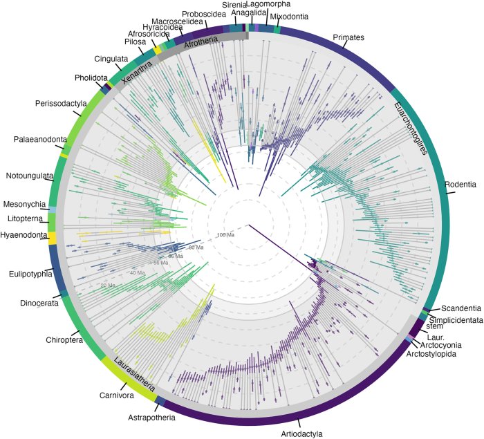
Fossil discoveries have been pivotal in shaping our understanding of human evolution. The discovery of “Lucy,” a remarkably preserved Australopithecus afarensis fossil, provided crucial insights into bipedalism and the early stages of hominin evolution. Subsequent finds, like those of Homo habilis and Homo erectus, have filled in gaps in the evolutionary record, showcasing the gradual changes and adaptations that occurred over millennia.
Each new fossil, meticulously studied and analyzed, adds another piece to the puzzle, offering a more complete picture of human origins.
The Development of Anthropological Techniques
The methodologies employed in studying human origins have undergone a dramatic transformation. Early approaches relied primarily on comparative anatomy and the interpretation of skeletal remains. However, the development of techniques like radiometric dating, which allows for the precise determination of the age of fossils, revolutionized the field. More recent advances in genetics, such as mitochondrial DNA analysis and genome sequencing, offer unprecedented insights into the genetic relationships between different hominin species.
Geographical Analysis and Human Migration
Understanding human migration patterns is crucial to comprehending the intricate story of human evolution. Geographical analysis, combined with archaeological data, helps researchers reconstruct the routes taken by early hominins as they dispersed across the globe. The distribution of archaeological sites and the characteristics of fossil remains found in different locations offer clues about environmental adaptations and cultural exchanges.
Theoretical Frameworks for Understanding Human Evolution
Various theoretical frameworks have been proposed to explain human evolution. One prominent framework is the punctuated equilibrium model, which suggests that evolution occurs in rapid bursts of change followed by periods of stability. Other models emphasize the importance of natural selection and environmental pressures in shaping human traits. These diverse perspectives, while often complementary, highlight the multifaceted nature of human evolution and the complexities of interpreting the fossil record.
Google Earth’s Role in Archaeological Discovery: Google Earth Helps Scientists Unearth Possible Human Ancestor
Google Earth, a seemingly simple tool for exploring the world, has become a powerful ally for archaeologists. Its satellite imagery and geographic data offer unprecedented opportunities to identify and investigate potential archaeological sites, even in remote and challenging terrains. This accessibility empowers researchers to visualize and analyze vast areas, accelerating the pace of discovery and potentially revolutionizing our understanding of human history.Archaeological research often involves meticulous ground surveys, but the sheer scale and accessibility of the Earth’s surface make such methods impractical in many cases.
Google Earth allows researchers to quickly and efficiently screen large areas, pinpointing regions that merit closer inspection. By overlaying historical maps and geographic information systems (GIS) data on satellite imagery, researchers can identify subtle features that might otherwise go unnoticed, leading to significant breakthroughs.
Satellite Imagery and Geographic Data in Archaeological Site Identification
Satellite imagery provides a bird’s-eye view of the landscape, revealing patterns and anomalies that may indicate buried archaeological features. Variations in vegetation, soil texture, or drainage patterns can hint at ancient settlements, burial grounds, or even transportation routes. For example, subtle depressions in a field, barely visible to the naked eye, might be ancient irrigation canals, which could be a key to understanding past agricultural practices.
Similarly, changes in land elevation or unusual geological formations can indicate the presence of structures or artifacts. Geographic data, including elevation models and historical maps, can further enhance these insights.
Identifying Potential Archaeological Sites
A key step in utilizing Google Earth for archaeological research is the identification of potential sites. The process typically involves careful analysis of satellite imagery, looking for unusual features or patterns. For instance, an unusually dense grouping of trees in a seemingly barren area might indicate a cluster of ancient buildings. Alternatively, a linear feature, like a ditch or a road, could suggest a trade route or a boundary marker.
By combining satellite imagery with historical maps and GIS data, archaeologists can build a clearer picture of the landscape’s history and pinpoint areas warranting further investigation.
Utilizing Google Earth for Locating Clues about Ancient Settlements or Pathways
Google Earth can be a valuable tool in pinpointing potential locations of ancient settlements and pathways. The imagery can reveal remnants of structures, such as walls, foundations, or even the Artikels of buildings, often obscured by modern development. These features might manifest as subtle changes in terrain or vegetation patterns. Similarly, anomalies in the landscape could indicate ancient roads or trails, which could provide clues about trade routes, communication networks, or migration patterns.
Historical maps overlaid on the satellite imagery can further contextualize these findings. An example of this could be identifying subtle variations in vegetation density along a suspected trade route, suggesting a pathway or a cleared area for easier transport.
Google Earth is proving to be a powerful tool for scientists, helping them unearth potential clues about our human ancestors. Recent discoveries, thanks to detailed imagery and analysis, are incredibly exciting. Meanwhile, it’s interesting to see how technology evolves in other sectors, like mobile devices, with Verizon launching a droid of a different color. Verizon launches a droid of a different color.
This fascinating development, though, doesn’t diminish the remarkable potential of Google Earth to reveal more about our past.
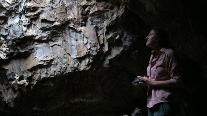
Google Earth in Remote or Difficult-to-Access Areas
In regions with limited access, Google Earth is invaluable. Archaeologists can use it to survey areas that are dangerous, difficult to traverse, or simply too large for traditional methods. This is particularly crucial in areas with ongoing conflict or natural disasters. Google Earth allows researchers to remotely identify and assess potential sites, minimizing risk and expense associated with physical surveys.
For instance, an archaeological team could use Google Earth to locate potential settlements within a mountainous region that is otherwise inaccessible.
Advantages and Limitations of Using Google Earth in Archaeological Research
Google Earth offers numerous advantages in archaeological research. It provides a relatively inexpensive and accessible platform for large-scale surveys. The ability to view vast areas from a high vantage point enables rapid screening of potential sites, saving valuable time and resources. The tool also allows for collaboration among researchers across geographical boundaries.However, Google Earth is not without limitations.
Satellite imagery resolution can be insufficient to detect very small or subtle features. Furthermore, the interpretation of imagery can be subjective, requiring careful consideration and validation through ground surveys. Finally, the presence of modern development or vegetation can obscure archaeological features. Archaeologists must critically evaluate the data, understanding that satellite imagery is a starting point, not a definitive answer.
The use of multiple data sources and corroborating evidence from historical documents or ground surveys is critical to avoid misinterpretations.
Case Studies of Using Google Earth in Human Ancestry Research
Google Earth, a seemingly simple tool for visualizing the world, has become a powerful ally for researchers delving into the mysteries of human ancestry. Its ability to display detailed satellite imagery, overlaid with geographical data, offers a unique perspective on potential sites of human activity, allowing researchers to explore vast areas quickly and efficiently. This approach has revolutionized archaeological discovery and provided new insights into the movements and adaptations of our ancestors.By overlaying historical maps and anthropological data onto high-resolution satellite imagery, researchers can identify subtle features that might be overlooked during traditional fieldwork.
This ability to “virtually excavate” landscapes has accelerated the process of identifying promising locations for further investigation, potentially saving significant time and resources.
Examples of Google Earth’s Role in Archaeological Discovery
Early adopters of this approach have demonstrated the efficacy of Google Earth in identifying potential human ancestor sites. The tool’s capacity to analyze vast swathes of terrain has been instrumental in unearthing evidence of ancient settlements and pathways, which could otherwise remain undiscovered.
- The identification of potential hominin footprints in East Africa: Researchers utilizing Google Earth imagery have pinpointed regions in East Africa exhibiting geological formations that could potentially preserve ancient hominin footprints. This allows for targeted ground surveys in these areas, potentially leading to significant discoveries about early hominin locomotion and behavior.
- The discovery of ancient river channels and settlements in the Amazon basin: Google Earth has proven useful in the Amazon, where the dense vegetation often obscures archaeological sites. The satellite imagery allowed researchers to visualize previously hidden river channels, which in turn revealed settlements that had been largely inaccessible through traditional methods. This enabled them to develop a more nuanced understanding of ancient human-environmental interactions.
- The exploration of potential human migration routes in Southeast Asia: By overlaying historical data and climate models on Google Earth’s satellite imagery, researchers can map potential migration routes. This approach has provided new insights into the dispersal patterns of early humans across Southeast Asia, potentially revealing previously unknown connections between different populations.
Types of Data Discovered Using Google Earth
The kinds of data discoverable using Google Earth are diverse and extend beyond simple site identification. This tool enables the mapping of ancient landscapes, including river systems, vegetation patterns, and elevation changes. These insights can shed light on the environmental factors that influenced human migration and adaptation.
Google Earth’s incredible detail is helping scientists uncover potential human ancestor sites. It’s fascinating how these tools can reveal ancient secrets. And while we’re on the topic of data and information, it’s also worth pondering how companies like Facebook collect and use our information, especially when it comes to things like social media engagement. For a look at the intriguing ways Facebook wants your two cents, check out this article: facebook wants your two cents.
Ultimately, Google Earth’s use in anthropological research continues to be a valuable tool for discovering more about our past.
- Geological formations: Analysis of geological formations in Google Earth imagery helps pinpoint areas that might contain fossilized remains or archaeological artifacts. The tool allows researchers to visualize geological features and their potential relationship to ancient human activities.
- Environmental data: The detailed imagery and mapping tools allow researchers to study ancient environments. This could include vegetation patterns, water sources, and elevation data, offering insights into how humans interacted with their surroundings.
- Settlement patterns: Researchers can use Google Earth to map and analyze ancient settlement patterns, potentially revealing information about population density, social structures, and economic activities.
Impact on Understanding Human Migration
The ability to analyze vast areas of the Earth using Google Earth has significantly impacted our understanding of human migration patterns. This approach offers a more comprehensive perspective, encompassing the environmental factors and geographical features that may have influenced the movement of our ancestors.
- Identification of migration routes: Google Earth facilitates the identification of potential migration routes by enabling the visualization of environmental corridors, rivers, and mountain ranges. This has helped researchers refine existing models of human migration and propose new hypotheses.
- Analysis of environmental influences: By studying environmental factors like climate change and resource availability, researchers can determine how these influences may have shaped human migration patterns. This allows for a more nuanced understanding of the interactions between humans and their environment.
Limitations and Potential Biases in Using Google Earth
Despite its usefulness, Google Earth is not without limitations. The accuracy of the data derived from the tool depends on the quality and resolution of the satellite imagery. Additionally, the interpretation of features observed in satellite imagery requires considerable expertise and context.
- Image resolution and quality: The resolution of satellite imagery can vary greatly, affecting the detail that can be observed. In some regions, the imagery may be too low-resolution to discern subtle features of interest.
- Subjectivity in interpretation: The interpretation of features observed in satellite imagery can be subjective, particularly in the absence of corroborating ground data. Careful consideration of alternative interpretations is crucial.
Potential for Future Research
The remarkable ability of Google Earth to visualize vast landscapes has opened exciting new avenues for exploring human ancestry. This potential is not limited to simply identifying possible sites; it can revolutionize the way we analyze and interpret data related to our evolutionary past. The integration of sophisticated algorithms and machine learning with Google Earth imagery could further enhance its effectiveness in archaeological research.
Hypothetical Project: Locating Potential Human Ancestor Sites in the African Rift Valley
This project aims to identify previously overlooked sites in the African Rift Valley, a region crucial to understanding early human evolution. By utilizing Google Earth’s high-resolution imagery and integrating it with geological data, researchers could pinpoint areas exhibiting geomorphological features indicative of ancient settlements. These features might include river terraces, eroded landscapes, or specific types of rock formations.
Furthermore, integrating paleoclimatic data and vegetation patterns will allow for a more holistic understanding of the environment in which these potential ancestors lived. This interdisciplinary approach could lead to the discovery of previously unknown sites with invaluable archaeological evidence.
Methods of Data Collection and Analysis using Google Earth
The table below Artikels different methods of data collection and analysis using Google Earth, juxtaposing them with traditional archaeological methods. Traditional methods often rely on extensive fieldwork and physical excavation, which can be costly and time-consuming. Google Earth provides a preliminary screening tool, reducing the geographical scope of fieldwork and concentrating efforts on promising areas.
| Method | Google Earth | Traditional Archaeology |
|---|---|---|
| Site Identification | Visual identification of potential sites based on geomorphological features, vegetation patterns, and other visual cues. | Extensive field surveys, historical records, and ethnographic research. |
| Preliminary Assessment | Assessment of the potential of a site using satellite imagery for clues like erosion patterns, rock formations, or human-made structures. | Fieldwalking, shovel testing, and preliminary surveys to identify potential sites for excavation. |
| Spatial Analysis | Analyzing the spatial relationships between potential sites and environmental factors using Google Earth’s tools. | Statistical analysis of collected data from excavated sites. |
| Data Visualization | Creation of 3D models and interactive maps for visualization and communication of findings. | Creation of site maps, drawings, and reports. |
Areas of Particular Usefulness for Human Ancestry Research
Google Earth can prove invaluable in several specific areas of human ancestor research. First, it allows for a rapid assessment of large geographical areas, identifying potential sites for more detailed investigation. Second, it facilitates the identification of previously overlooked or inaccessible regions. Third, it enables researchers to examine the spatial distribution of potential sites relative to environmental factors, allowing for the development of more sophisticated models of human adaptation and migration.
Potential Future Applications
Google Earth can be applied in various ways to further human ancestor research. These include:
- Mapping migration patterns: By studying the distribution of potential sites across different regions and periods, researchers can gain insights into human migration patterns. This approach could potentially reveal the factors that drove these movements. For instance, tracing potential settlement locations in response to climate shifts.
- Identifying resource availability: Google Earth can help pinpoint areas with abundant resources, such as water sources, food, and minerals, which could have played a crucial role in the distribution of human populations.
- Developing predictive models: By combining Google Earth imagery with data on climate change, researchers can develop predictive models to identify potential human ancestor sites in different environmental conditions.
- Enhancing public engagement: The interactive nature of Google Earth makes it a powerful tool for engaging the public in human ancestry research, allowing them to explore and visualize these discoveries.
Steps in Identifying and Analyzing Potential Archaeological Sites using Google Earth
- Preliminary Reconnaissance: Identify potential areas based on geomorphological features, vegetation patterns, and other visual clues using Google Earth’s imagery.
- Data Collection: Collect relevant data such as satellite imagery, topographical maps, and paleoclimatic data from various sources. Overlay this data on the Google Earth platform.
- Spatial Analysis: Analyze the spatial relationships between the identified sites and environmental factors. This could involve measuring distances to water sources, calculating elevation changes, or identifying vegetation types.
- Site Verification: Ground-truthing is essential. This involves confirming the potential site through field surveys and excavation. Google Earth can help refine the targets for these expeditions.
- Data Interpretation: Analyze the collected data to determine the significance of the site in relation to human evolution.
Data Visualization and Interpretation

Uncovering the secrets of human ancestry often hinges on the ability to interpret geographical data. Google Earth, with its vast repository of imagery and data layers, provides a powerful platform for visualizing and analyzing potential clues. This exploration delves into the practical application of Google Earth features, emphasizing the importance of effective data visualization for a clear understanding of the geographical context of human ancestor research.
Types of Data Google Earth Provides
Understanding the different data types available on Google Earth is crucial for focused analysis. These data layers often reveal key information, such as historical land use, vegetation patterns, and even ancient settlements. Successfully leveraging these resources requires recognizing their relevance to human ancestor research.
| Data Type | Description | Relevance to Human Ancestry |
|---|---|---|
| Satellite Imagery | High-resolution photographs of the Earth’s surface, often going back decades. | Allows for identification of landscape changes over time, potential migration routes, and evidence of past settlements. |
| Elevation Data | Detailed information about the height of the terrain. | Helps understand environmental factors influencing human settlement patterns, water sources, and potential migration corridors. |
| Historical Maps | Maps from past centuries, showing land ownership, settlement layouts, and other features. | Provides context for understanding land use changes and human occupation patterns over time, crucial for pinpointing areas of potential interest. |
| Geographic Information System (GIS) Data | Data layers providing additional information like population density, climate patterns, or archeological sites. | Provides additional context for interpreting the satellite imagery and maps, offering insights into past environmental and social factors. |
Using Google Earth Features
Google Earth offers a suite of tools to analyze the data relevant to human ancestor research. Mastering these tools is essential for extracting meaningful insights from the vast amount of data.
- Layers: Activating and deactivating layers allows users to focus on specific data types. For example, overlaying historical maps with satellite imagery can highlight changes in settlement patterns over time. This targeted approach helps isolate significant trends.
- Measurement Tools: Google Earth’s measurement tools, including distance and area calculators, are invaluable. For instance, measuring distances between potential sites can help determine if a location was feasible for travel during a certain time period. Calculating the area of potential settlements can give insights into population density.
- 3D Views: Using the 3D view is crucial for understanding the terrain’s impact on human settlements and resource availability. The 3D view can show the elevation changes over a large area, which could influence ancient human migration routes.
Interpreting Geographical Data
Effective interpretation requires a nuanced understanding of the interplay between geography, environment, and human behavior. Interpreting data requires critical thinking, looking for patterns, and drawing connections between different data points.
Google Earth’s amazing capabilities are helping scientists uncover potential human ancestor sites. It’s fascinating how these tools can reveal clues about our past. But while we’re piecing together our history, there’s also the mystery of the HPS Dreamscreen, requiring interpretation, as detailed in this article. Perhaps these discoveries, both earthly and seemingly ethereal, offer glimpses into the intricate tapestry of our existence and the ongoing quest for understanding.
- Identifying Patterns: Looking for recurring patterns in the data, such as the concentration of settlements near water sources or the presence of specific vegetation types near archaeological sites, can reveal significant insights. For example, the location of springs or rivers may be linked to ancient settlement patterns.
- Considering Environmental Factors: Analyzing environmental data like climate patterns and vegetation types helps understand how the environment influenced human settlements. The presence of particular types of vegetation might indicate a specific period or environment suitable for human occupation.
- Connecting to Other Research: Combining Google Earth findings with data from other disciplines, such as archaeology, anthropology, and paleoclimatology, provides a more comprehensive picture. For example, comparing Google Earth’s data on ancient riverbeds with archeological findings about settlement locations can provide insights into past water resources.
Presenting Findings, Google earth helps scientists unearth possible human ancestor
Clear and accessible presentation is key to sharing the results of a Google Earth study effectively.
- Visualizations: Creating maps with clear overlays, highlighting key locations and trends, and using color-coding to represent different data points is a powerful approach. For instance, a map showcasing the distribution of potential human ancestor settlements could use different colors to represent different time periods.
- Interactive Presentations: Employing interactive Google Earth files allows others to explore the data firsthand. This enables viewers to interact with the data, and provides a powerful method to communicate the findings.
- Written Reports: Complementing visualizations with detailed written reports providing context and explanations is essential. These reports should include references to the data used, a summary of the methodology, and a clear interpretation of the findings. This detailed information provides greater context to the geographical data found.
Ethical Considerations and Limitations
Unearthing the secrets of human ancestry through geographical data like Google Earth presents exciting opportunities but also significant ethical challenges. Carefully navigating these considerations is crucial to ensure responsible and respectful research. The potential for misuse, unintended consequences, and disrespect for cultural heritage necessitates a mindful approach. This section explores the ethical considerations, limitations, and potential biases associated with this innovative method.
Ethical Considerations in Using Publicly Accessible Geographical Data
The accessibility of geographical data, including that available through Google Earth, raises ethical concerns regarding privacy and potential misuse. Researchers must be vigilant in ensuring their data collection and analysis methods do not violate individual privacy rights. For example, identifying specific individuals or locations in sensitive regions without proper consent could have severe repercussions.
Benefits and Risks of Using Google Earth in Sensitive or Protected Areas
Utilizing Google Earth in sensitive or protected areas carries both potential benefits and inherent risks. Identifying archaeological sites and patterns of human activity in these areas can provide valuable insights into human history. However, unauthorized access or improper data collection practices can harm local communities and ecosystems. A crucial aspect of this balance is obtaining explicit consent from relevant authorities and communities before undertaking any research in such regions.
A meticulous and transparent methodology is essential.
Potential Biases in Data Collected Through Google Earth
Data collected through Google Earth is not without biases. The perspectives captured by satellite imagery can be affected by factors like cloud cover, vegetation density, and the time of year. The availability of imagery also varies depending on the region. These inherent limitations in data collection must be acknowledged and considered in the analysis. Researchers should employ strategies to mitigate such biases, including employing multiple data sources and diverse methodologies.
Respecting Cultural Heritage Sites When Using Google Earth for Research
Respecting cultural heritage sites is paramount. Researchers using Google Earth should prioritize ethical considerations and avoid actions that could damage or desecrate sacred sites. This includes adhering to all applicable regulations and guidelines and working in collaboration with local communities. Furthermore, researchers must be aware of the potential for cultural misinterpretations and proactively engage with local experts and communities to ensure accurate and sensitive analyses.
Limitations of Using Google Earth in Understanding Complex Aspects of Human Evolution
Google Earth provides a valuable tool for identifying potential sites and patterns, but it is not a substitute for on-site archaeological investigation. It offers limited insight into the complex social, cultural, and environmental factors that shaped human evolution. Interpreting the vast expanse of human history from satellite imagery alone is inherently limited. Researchers should utilize Google Earth in conjunction with traditional archaeological methods, field surveys, and laboratory analyses to gain a comprehensive understanding.
A holistic approach is crucial.
Closing Notes
In conclusion, Google Earth is proving to be a powerful tool in human ancestry research. Its ability to provide a comprehensive view of the earth’s surface enables scientists to uncover potential human ancestor sites and trace migration patterns. While not without limitations, the technology presents a new avenue for exploration, prompting further research and exciting possibilities for the future.
The combination of historical analysis with advanced mapping technology is reshaping our understanding of human origins.